
Estimation of agricultural areas through cloud processing for the Potosino highlands
DOI:
https://doi.org/10.29312/remexca.v16i1.3369Keywords:
crops, google earth engine, QGISAbstract
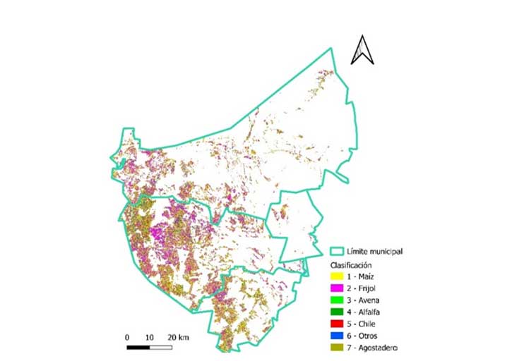
Las imágenes satelitales ópticas son bancos de información poderosos para la estimación de superficies agrícolas. El objetivo de este estudio fue estimar las superficies agrícolas en los municipios de Salinas, Santo Domingo y Villa de Ramos, mediante el procesamiento en la nube de imágenes satelitales y su comparación con la tecnología de INEGI-tradicional. El trabajo se realizó limitado a la zona agrícola, la cual suma una superficie de 190 871 ha, de esta, el 86% son de temporal. El período de estudio fue de octubre 2020 a octubre 2021. Se aplicaron seis algoritmos de clasificación, tres para INEGI-tradicional: mínima distancia, máxima verosimilitud y spectral angle mapper en QGIS 3.18 y tres para el procesamiento en la nube: classification and regression trees, random forest y support vector machine con Google Earth Engine. Se estimaron las superficies de los principales cultivos (maíz, frijol, avena, alfalfa y chile) para la zona de estudio, a partir de 294 muestras de campo. Para el procesamiento de imágenes Sentinel-2, se utilizó una geomediana libre de nubes. Los resultados de las matrices de confusión indicaron qué clasificaciones fueron más precisas, los valores fueron de: 89% para classification and regression trees y random forest, 59% para support vector machine, 48% para mínima distancia, 43% para máxima verosimilitud y 46% para spectral angle mapper. Los algoritmos classification and regression trees y random forest superaron en precisión a los demás clasificadores evaluados, estos estimaron las superficies agrícolas de maíz y frijol más cercanas entre sí (80 131 y 98 138 ha en maíz y 60 174 y 60 358 ha en frijol) en comparación a los clasificadores restantes.
Downloads
References
Abatzoglou, J. T.; Dobrowski, S. Z.; Parks, S. A. and Hegewisch, K. C. 2018. Terraclimate, a high-resolution global dataset of monthly climate and climatic water balance from 1958-2015, Scientific Data. 5(1):1-12. Doi:10.1038/sdata.2017.191.
Aghababaei, M.; Ebrahimi, A.; Naghipour, A.; Asadi, E.; and Verrelst, J. 2021. Vegetation types mapping using multi-temporal Landsat images in the google earth engine platform. Remote Sensing. 13(22):4683-15. https://doi.org/10.3390/rs13224683.
Aguilar, L. J. 2016. Big data, análisis de grandes volúmenes de datos en organizaciones. Primera edición. Alfaomega Grupo Editor. México, DF.
Amani, M.; Kakooei, M.; Moghimi, A.; Ghorbanian, A.; Ranjgar, B.; Mahdavi, S.; Davidson, A.; Fisette, T.; Rollin, P.; Brisco, B. and Mohammadzadeh, A. 2020. Application of google earth engine cloud computing platform, sentinel imagery and neural networks for crop mapping in Canada. Remote Sens. 12(21):3561-18. https://doi.org/10.3390/rs12213561.
Bravo, L. A. G.; González, G. H. y Rumayor, R. A. 2006. Sequía: vulnerabilidad, impacto y tecnología para afrontarla en el Norte-Centro de México. Instituto Nacional de Investigaciones Forestales, Agrícolas y Pecuarias (INIFAP)-CIRNOC-Campo Experimental Zacatecas. 2ª Edición. Libro técnico núm. 4. 297 p.
CONAGUA. 2020. Comisión Nacional del Agua. Estaciones meteorológicas automáticas (EMAS). https://smn.conagua.gob.mx/es/observando-el-tiempo/estaciones-meteorologicas-automaticas-ema-s.
Gallardo-Cruz, A; Fernández-Montes, O. A. y Rives, C. 2019. Detección de amenazas y oportunidades para la conservación en la cuenca baja del Usumacinta a partir de técnicas de percepción remota. Ecosistemas. 28(2):82-99. https://doi.org/10.7818/ECOS.1611.
German, L. A.; Vitale, J. P.; Waldman, C. P. y Castañeda N. 2019. Estimación de superficie de invernáculos en el partido de la plata, mediante dos algoritmos de inteligencia artificial en la plataforma Google Earth Engine. In: XI Congreso de AgroInformática (CAI) JAIIO. 48:1-11 http://sedici.unlp.edu.ar/handle/10915/88069.
INEGI. 2008. Instituto Nacional de Estadística y Geografía. Unidades climáticas. https://www.inegi.org.mx/temas/climatologia/.
INEGI. 2020a. Instituto Nacional de Estadística y Geografía. Marco geoestadístico nacional (MGN) https://www.inegi.org.mx/temas/mg/#Descargas.
INEGI. 2020b. Instituto Nacional de Estadística y Geografía. Geomediana Landsat https://www.inegi.org.mx/investigacion/geomediana/.
Killough, B. 2018. Overview of the open data cube initiative. In: IGARSS 2018-2018 IEEE international geoscience and remote sensing symposium. 8629-8632 pp.
Kok, Z. H.; Shariff, A. R. M.; Alfatni, M. S. M. and Kairunniza-Bejo, S. 2021. Support vector machine in precision agriculture: a review. Comput. Electron. Agric. 191:106546-12. https://doi.org/10.1016/j.compag.2021.106546.
Mananze, S.; Pôças, I. and Cunha, M. 2020. Mapping and assessing the dynamics of shifting agricultural landscapes using google earth engine cloud computing, a case study in Mozambique. Remote Sensing. 12(8):1279-23. https://doi.org/10.3390/rs12081279.
Núñez-López, D.; Muñoz-Robles, V. M.; Reyes-Gómez. I.; Velasco-Velasco, I. y Gadsden-Esperza, H. 2007. Caracterización de la sequía a diversas escalas de tiempo en México. Agrociencia. 41(3):253-262.
Panagiotakis, C.; Papadakis, H. and Fragopoulou, P. 2021. A dual hybrid recommender system based on SCoR and the random forest. Computer Science and Information Systems. 18(1):115-128. https://doi.org/10.2298/CSIS200515046P.
Perilla, G. A. y Mas, J. F. 2020. Google Earth Engine (GEE): una poderosa herramienta que vincula el potencial de los datos masivos y la eficacia del procesamiento en la nube. Investigaciones Geográficas. 101:1-6. https://doi.org/10.14350/rig.59929.
Roberts, D.; Mueller, N. and Mcintyre, A. 2017. High-dimensional pixel composites from earth observation time series. IEEE Transactions on Geoscience and Remote Sensing. 55(11):6254-6264. Doi: 10.1109/TGRS.2017.2723896.
Romero, F. S. 2006. La teledetección satelital y los sistemas de protección ambiental. Quivera Revista de Estudios Territoriales. 8(1):315-356.
Sánchez-Pozo, N.; Trilles-Oliver, S.; Solé-Ribalta, A.; Lorente-Leyva, L.; Mayorca-Torres, D. and Peluffo-Ordóñez D. 2021. Algorithms air quality estimation: a comparative study of stochastic and heuristic predictive models, lecture notes in computer science. 12886:293-304. https://doi.org/10.1007/978-3-030-86271-8-25.
SIAP. 2020. Servicio de Información Agroalimentaria y Pesquera. Frontera agrícola serie II. http://infosiap.siap.gob.mx/gobmx/datosAbiertos.php.
SIAP. 2021. Servicio de Información Agroalimentaria y Pesquera. Avance de siembras y cosechas. https://nube.siap.gob.mx/cierreagricola/.
Strzelecka, A. and Zawadzka, D. 2021. Application of classification and regression tree (CRT) analysis to identify the agricultural households at risk of financial exclusion. Procedia Computer Science. 192:4532-4541. https://doi.org/10.1016/j.procs.2021.09.231.
TA, V. G.; Douriet-Angulo, A.; Tirado-Ramírez, M. A.; López-Urquídez, G. A. and López-Orona, C. A. 2022. Root rot and wilt caused by Fusarium Nygamai of bean (Phaseolus vulgaris) in Sinaloa, México. Plant Disease. 106(10):2748-2. https://doi.org/10.1094/pdis-01-22-0123-pdn.
Vega, P. J. J.; Zárate-Gómez, R.; Minaya, V. R. J.; Brañas, M. M. y Benavides, R. J. E. 2019. Predicción de la pérdida de la cobertura vegetal por aumento de áreas urbanas en Iquitos, Perú. Ciencia Amazónica. 7(1):37-50. https://doi.org/10.22386/ca.v7i1.263.
Venkatappa, M.; Sasaki, N.; Shrestha, R. P.; Tripathi, N. K. and Ma, H. O. 2019. Determination of vegetation thresholds for assessing land use and land use changes in Cambodia using the google earth engine cloud-computing platform. Remote Sensing. 11(13):1514-30. https://doi.org/10.3390/rs11131514.
Downloads
Published
How to Cite
Issue
Section
License
Copyright (c) 2025 Revista Mexicana de Ciencias Agrícolas

This work is licensed under a Creative Commons Attribution-NonCommercial 4.0 International License.
The authors who publish in Revista Mexicana de Ciencias Agrícolas accept the following conditions:
In accordance with copyright laws, Revista Mexicana de Ciencias Agrícolas recognizes and respects the authors’ moral right and ownership of property rights which will be transferred to the journal for dissemination in open access. Invariably, all the authors have to sign a letter of transfer of property rights and of originality of the article to Instituto Nacional de Investigaciones Forestales, Agrícolas y Pecuarias (INIFAP) [National Institute of Forestry, Agricultural and Livestock Research]. The author(s) must pay a fee for the reception of articles before proceeding to editorial review.
All the texts published by Revista Mexicana de Ciencias Agrícolas —with no exception— are distributed under a Creative Commons License Attribution-NonCommercial 4.0 International (CC BY-NC 4.0), which allows third parties to use the publication as long as the work’s authorship and its first publication in this journal are mentioned.
The author(s) can enter into independent and additional contractual agreements for the nonexclusive distribution of the version of the article published in Revista Mexicana de Ciencias Agrícolas (for example include it into an institutional repository or publish it in a book) as long as it is clearly and explicitly indicated that the work was published for the first time in Revista Mexicana de Ciencias Agrícolas.
For all the above, the authors shall send the Letter-transfer of Property Rights for the first publication duly filled in and signed by the author(s). This form must be sent as a PDF file to: revista_atm@yahoo.com.mx; cienciasagricola@inifap.gob.mx; remexca2017@gmail.
This work is licensed under a Creative Commons Attribution-Noncommercial 4.0 International license.

