Estimación de superficies agrícolas mediante procesamiento en la nube para el altiplano potosino
DOI:
https://doi.org/10.29312/remexca.v16i1.3369Palabras clave:
cultivos, google earth engine, QGISResumen
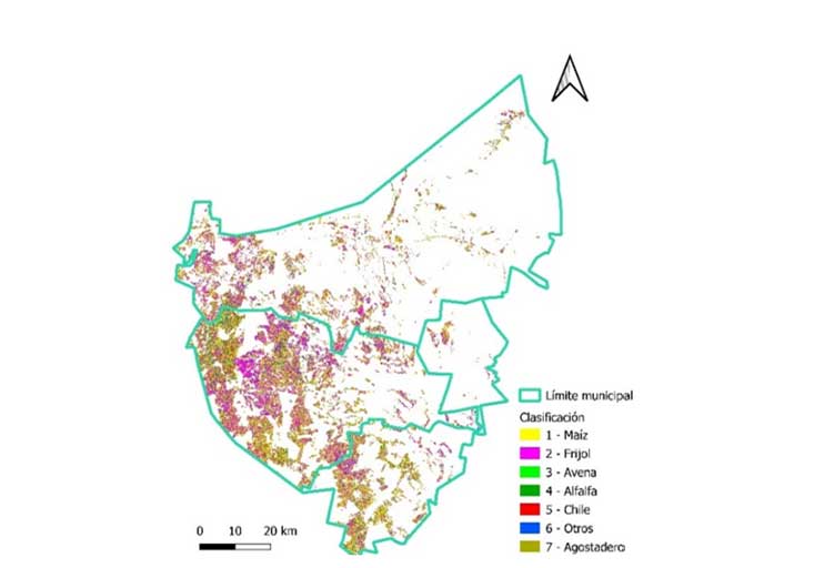
Optical satellite imagery is a powerful information bank for estimating agricultural areas. This study aimed to estimate agricultural areas in the municipalities of Salinas, Santo Domingo, and Villa de Ramos through cloud processing of satellite images and their comparison with the traditional-INEGI technology. The work was carried out limited to the agricultural area, which totals an area of 190 871 ha, of which 86% are rainfed. The study period was from October 2020 to October 2021. Six classification algorithms were applied; three for traditional-INEGI: minimum distance, maximum likelihood, and spectral angle mapper in QGIS 3.18; and three for cloud processing: classification and regression trees, random forest, and support vector machine with Google Earth Engine. The areas of the main crops (corn, beans, oats, alfalfa, and chili) were estimated for the study area based on 294 field samples. For Sentinel-2 image processing, a cloud-free geomedian was used. The results of the confusion matrices indicated which classifications were more accurate; the values were 89% for classification and regression trees and random forest, 59% for support vector machine, 48% for minimum distance, 43% for maximum likelihood, and 46% for spectral angle mapper. The classification and regression trees and random forest algorithms outperformed the other classifiers evaluated in accuracy, estimating the corn and bean agricultural areas closest to each other (80 131 and 98 138 ha in corn and 60 174 and 60 358 ha in beans) compared to the remaining classifiers.
Descargas
Citas
Abatzoglou, J. T.; Dobrowski, S. Z.; Parks, S. A. and Hegewisch, K. C. 2018. Terraclimate, a high-resolution global dataset of monthly climate and climatic water balance from 1958-2015, Scientific Data. 5(1):1-12. Doi:10.1038/sdata.2017.191.
Aghababaei, M.; Ebrahimi, A.; Naghipour, A.; Asadi, E.; and Verrelst, J. 2021. Vegetation types mapping using multi-temporal Landsat images in the google earth engine platform. Remote Sensing. 13(22):4683-15. https://doi.org/10.3390/rs13224683.
Aguilar, L. J. 2016. Big data, análisis de grandes volúmenes de datos en organizaciones. Primera edición. Alfaomega Grupo Editor. México, DF.
Amani, M.; Kakooei, M.; Moghimi, A.; Ghorbanian, A.; Ranjgar, B.; Mahdavi, S.; Davidson, A.; Fisette, T.; Rollin, P.; Brisco, B. and Mohammadzadeh, A. 2020. Application of google earth engine cloud computing platform, sentinel imagery and neural networks for crop mapping in Canada. Remote Sens. 12(21):3561-18. https://doi.org/10.3390/rs12213561.
Bravo, L. A. G.; González, G. H. y Rumayor, R. A. 2006. Sequía: vulnerabilidad, impacto y tecnología para afrontarla en el Norte-Centro de México. Instituto Nacional de Investigaciones Forestales, Agrícolas y Pecuarias (INIFAP)-CIRNOC-Campo Experimental Zacatecas. 2ª Edición. Libro técnico núm. 4. 297 p.
CONAGUA. 2020. Comisión Nacional del Agua. Estaciones meteorológicas automáticas (EMAS). https://smn.conagua.gob.mx/es/observando-el-tiempo/estaciones-meteorologicas-automaticas-ema-s.
Gallardo-Cruz, A; Fernández-Montes, O. A. y Rives, C. 2019. Detección de amenazas y oportunidades para la conservación en la cuenca baja del Usumacinta a partir de técnicas de percepción remota. Ecosistemas. 28(2):82-99. https://doi.org/10.7818/ECOS.1611.
German, L. A.; Vitale, J. P.; Waldman, C. P. y Castañeda N. 2019. Estimación de superficie de invernáculos en el partido de la plata, mediante dos algoritmos de inteligencia artificial en la plataforma Google Earth Engine. In: XI Congreso de AgroInformática (CAI) JAIIO. 48:1-11 http://sedici.unlp.edu.ar/handle/10915/88069.
INEGI. 2008. Instituto Nacional de Estadística y Geografía. Unidades climáticas. https://www.inegi.org.mx/temas/climatologia/.
INEGI. 2020a. Instituto Nacional de Estadística y Geografía. Marco geoestadístico nacional (MGN) https://www.inegi.org.mx/temas/mg/#Descargas.
INEGI. 2020b. Instituto Nacional de Estadística y Geografía. Geomediana Landsat https://www.inegi.org.mx/investigacion/geomediana/.
Killough, B. 2018. Overview of the open data cube initiative. In: IGARSS 2018-2018 IEEE international geoscience and remote sensing symposium. 8629-8632 pp.
Kok, Z. H.; Shariff, A. R. M.; Alfatni, M. S. M. and Kairunniza-Bejo, S. 2021. Support vector machine in precision agriculture: a review. Comput. Electron. Agric. 191:106546-12. https://doi.org/10.1016/j.compag.2021.106546.
Mananze, S.; Pôças, I. and Cunha, M. 2020. Mapping and assessing the dynamics of shifting agricultural landscapes using google earth engine cloud computing, a case study in Mozambique. Remote Sensing. 12(8):1279-23. https://doi.org/10.3390/rs12081279.
Núñez-López, D.; Muñoz-Robles, V. M.; Reyes-Gómez. I.; Velasco-Velasco, I. y Gadsden-Esperza, H. 2007. Caracterización de la sequía a diversas escalas de tiempo en México. Agrociencia. 41(3):253-262.
Panagiotakis, C.; Papadakis, H. and Fragopoulou, P. 2021. A dual hybrid recommender system based on SCoR and the random forest. Computer Science and Information Systems. 18(1):115-128. https://doi.org/10.2298/CSIS200515046P.
Perilla, G. A. y Mas, J. F. 2020. Google Earth Engine (GEE): una poderosa herramienta que vincula el potencial de los datos masivos y la eficacia del procesamiento en la nube. Investigaciones Geográficas. 101:1-6. https://doi.org/10.14350/rig.59929.
Roberts, D.; Mueller, N. and Mcintyre, A. 2017. High-dimensional pixel composites from earth observation time series. IEEE Transactions on Geoscience and Remote Sensing. 55(11):6254-6264. Doi: 10.1109/TGRS.2017.2723896.
Romero, F. S. 2006. La teledetección satelital y los sistemas de protección ambiental. Quivera Revista de Estudios Territoriales. 8(1):315-356.
Sánchez-Pozo, N.; Trilles-Oliver, S.; Solé-Ribalta, A.; Lorente-Leyva, L.; Mayorca-Torres, D. and Peluffo-Ordóñez D. 2021. Algorithms air quality estimation: a comparative study of stochastic and heuristic predictive models, lecture notes in computer science. 12886:293-304. https://doi.org/10.1007/978-3-030-86271-8-25.
SIAP. 2020. Servicio de Información Agroalimentaria y Pesquera. Frontera agrícola serie II. http://infosiap.siap.gob.mx/gobmx/datosAbiertos.php.
SIAP. 2021. Servicio de Información Agroalimentaria y Pesquera. Avance de siembras y cosechas. https://nube.siap.gob.mx/cierreagricola/.
Strzelecka, A. and Zawadzka, D. 2021. Application of classification and regression tree (CRT) analysis to identify the agricultural households at risk of financial exclusion. Procedia Computer Science. 192:4532-4541. https://doi.org/10.1016/j.procs.2021.09.231.
TA, V. G.; Douriet-Angulo, A.; Tirado-Ramírez, M. A.; López-Urquídez, G. A. and López-Orona, C. A. 2022. Root rot and wilt caused by Fusarium Nygamai of bean (Phaseolus vulgaris) in Sinaloa, México. Plant Disease. 106(10):2748-2. https://doi.org/10.1094/pdis-01-22-0123-pdn.
Vega, P. J. J.; Zárate-Gómez, R.; Minaya, V. R. J.; Brañas, M. M. y Benavides, R. J. E. 2019. Predicción de la pérdida de la cobertura vegetal por aumento de áreas urbanas en Iquitos, Perú. Ciencia Amazónica. 7(1):37-50. https://doi.org/10.22386/ca.v7i1.263.
Venkatappa, M.; Sasaki, N.; Shrestha, R. P.; Tripathi, N. K. and Ma, H. O. 2019. Determination of vegetation thresholds for assessing land use and land use changes in Cambodia using the google earth engine cloud-computing platform. Remote Sensing. 11(13):1514-30. https://doi.org/10.3390/rs11131514.

Descargas
Publicado
Cómo citar
Número
Sección
Licencia
Derechos de autor 2025 Revista Mexicana de Ciencias Agrícolas

Esta obra está bajo una licencia internacional Creative Commons Atribución-NoComercial 4.0.
Los autores(as) que publiquen en Revista Mexicana de Ciencias Agrícolas aceptan las siguientes condiciones:
De acuerdo con la legislación de derechos de autor, Revista Mexicana de Ciencias Agrícolas reconoce y respeta el derecho moral de los autores(as), así como la titularidad del derecho patrimonial, el cual será cedido a la revista para su difusión en acceso abierto.
Los autores(as) deben de pagar una cuota por recepción de artículos antes de pasar por dictamen editorial. En caso de que la colaboración sea aceptada, el autor debe de parar la traducción de su texto al inglés.
Todos los textos publicados por Revista Mexicana de Ciencias Agrícolas -sin excepción- se distribuyen amparados bajo la licencia Creative Commons 4.0 atribución-no comercial (CC BY-NC 4.0 internacional), que permite a terceros utilizar lo publicado siempre que mencionen la autoría del trabajo y a la primera publicación en esta revista.
Los autores/as pueden realizar otros acuerdos contractuales independientes y adicionales para la distribución no exclusiva de la versión del artículo publicado en Revista Mexicana de Ciencias Agrícolas (por ejemplo incluirlo en un repositorio institucional o darlo a conocer en otros medios en papel o electrónicos) siempre que indique clara y explícitamente que el trabajo se publicó por primera vez en Revista Mexicana de Ciencias Agrícolas.
Para todo lo anterior, los autores(as) deben remitir el formato de carta-cesión de la propiedad de los derechos de la primera publicación debidamente requisitado y firmado por los autores(as). Este formato debe ser remitido en archivo PDF al correo: revista_atm@yahoo.com.mx; revistaagricola@inifap.gob.mx.
Esta obra está bajo una licencia de Creative Commons Reconocimiento-No Comercial 4.0 Internacional.


