Modeling of changes in cover and land use in Nacajuca, Tabasco

Authors

  • Miguel Angel Palomeque de la Cruz División Académica de Ciencias Biológicas-Universidad Juárez Autónoma de Tabasco. Carretera Villahermosa-Cárdenas km 0.5, Villahermosa, Tabasco, México. CP. 86040. Tel. 993 3581500 https://orcid.org/0000-0003-3957-8160
  • Silvia del Carmen Ruiz Acosta Tecnológico Nacional de México-IT Zona Olmeca. Prolongación Ignacio Zaragoza s/n, Villa Ocuitzapotlan, Centro, Tabasco, México. CP. 86270. Tel. 993 3210608 https://orcid.org/0000-0002-3319-0117
  • Rodimiro Ramos Reyes El Colegio de la Frontera Sur-Unidad Villahermosa. El Colegio de la Frontera Sur-LAIGE. Carretera Villahermosa-Reforma, km 15.5 s/n, Ranchería Guineo, 2da. Sección, Villahermosa, Tabasco, México. CP. 86280. Tel. 993 3136110 https://orcid.org/0000-0003-3957-8160
  • Miguel Alberto Magaña Alejandro División Académica de Ciencias Biológicas-Universidad Juárez Autónoma de Tabasco. Carretera Villahermosa-Cárdenas km 0.5, Villahermosa, Tabasco, México. CP. 86040. Tel. 993 3581500 https://orcid.org/0000-0001-5024-1580
  • Adalberto Galindo Alcantara División Académica de Ciencias Biológicas-Universidad Juárez Autónoma de Tabasco. Carretera Villahermosa-Cárdenas km 0.5, Villahermosa, Tabasco, México. CP. 86040. Tel. 993 3581500 http://orcid.org/0000-0001-9628-982X

DOI:

https://doi.org/10.29312/remexca.v12i4.2622

Keywords:

environmental disturbance, geographic information systems, land use change modeler, territorial ecological planning

Abstract

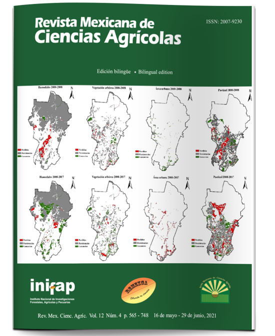
The urban growth of Nacajuca, Tabasco, has transformed the natural system, being necessary to know the current spatial configuration of natural covers and artificial uses in order to provide information on spatial dynamics for ecological planning. The objective of the study was to model changes in covers and land use (2000, 2008 and 2017), through a multitemporal analysis using the Land Change Modeler for ecological sustainability of IDRISI. The results indicate that in the period 2000-2008, there was a decrease in wetlands (1 796 ha) and a slight increase in tree vegetation (689 ha), contrary to urban growth (796 ha) and a large increase in grassland (2 168 ha). In the second period (2008-2017), the greatest loss of wetlands (3 995 ha) and tree vegetation (1 233 ha) was detected, while the urban area and grassland had the greatest increases (1 365 and 4 378 ha). The main transitions were first, the change from large wetland covers to grassland and secondly the transformation from grassland to urban area. The disturbance relates to the dynamics of the metropolitan area of Villahermosa and coincides with the loss of large wetland areas in the areas analyzed. In view of this, the alternatives to reduce the effects of land use change are the elaboration of the territorial ecological planning and the urban development program in which the use of Geographic Information Systems, environmental remote sensing and the implementation of geomatic models for spatial analysis are involved.

Downloads

Download data is not yet available.

Author Biographies

Miguel Angel Palomeque de la Cruz, División Académica de Ciencias Biológicas-Universidad Juárez Autónoma de Tabasco. Carretera Villahermosa-Cárdenas km 0.5, Villahermosa, Tabasco, México. CP. 86040. Tel. 993 3581500

Licenciado en Biología, Maestro en Ciencias Ambientales y Doctor en Ciencias en Ecología perteneciente al Cuerpo Académico de Ordenamiento Ecológico y Análisis Socio ambiental en la Universidad Juárez Autónoma de Tabasco. Sistema Nacional de Investigadores Nivel 1 del Área V Ciencias Sociales. Con conocimientos de Sistemas de Información Geográfica, Teledetección ambiental, Geomática. Durante 2017 al presente, ha colaborado en un proyecto sobre manejo de cuencas hidrográficas y un programa de desarrollo urbano metropolitano de Villahermosa. Cuenta con siete publicaciones científicas sobre urbanismo, cambio de uso del suelo, modelos geomáticos y ganadería bovina.

Silvia del Carmen Ruiz Acosta, Tecnológico Nacional de México-IT Zona Olmeca. Prolongación Ignacio Zaragoza s/n, Villa Ocuitzapotlan, Centro, Tabasco, México. CP. 86270. Tel. 993 3210608

Egresada de la Licenciatura en Biología de la de la UJAT

Maestría en Ciencias de la Educación. IUP

Doctorado en Ciencias de la Educación. (UM)

Profesor titular C de TC en el Instituto Tecnológico de la Zona Olmeca

A lo largo de su carrera académica ha publicado varios libros, así como diversos artículos en revistas científicas nacionales e internacionales.

Miembro del Sistema Nacional de Investigadores de CONACYT

Rodimiro Ramos Reyes, El Colegio de la Frontera Sur-Unidad Villahermosa. El Colegio de la Frontera Sur-LAIGE. Carretera Villahermosa-Reforma, km 15.5 s/n, Ranchería Guineo, 2da. Sección, Villahermosa, Tabasco, México. CP. 86280. Tel. 993 3136110

Doctor en ciencias en ecología y manejo de sistemas tropicales, con la tesis Vulnerabilidad física de la zona costera de Tabasco y Campeche, México. He impartido cursos a nivel licenciatura y posgrado, todo relacionado con sistema de información geográfica. Se ha colaborado como director y Asesor de estudiantes de Licenciatura y Maestría. También he participado en diversos trabajos de investigación, en Cambios de usos y tipos de suelos, clasificación de humedales, vulnerabilidad y cambio climático. Soy árbitro en varias revistas científicas, de divulgación y en otros eventos de talla nacional e internacional. A su vez he publicado más de 15 artículos científicos, pertenezco al Sistema Estatal de Investigadores de Tabasco y al Sistema Nacional de Investigadores Nivel 1

Adalberto Galindo Alcantara, División Académica de Ciencias Biológicas-Universidad Juárez Autónoma de Tabasco. Carretera Villahermosa-Cárdenas km 0.5, Villahermosa, Tabasco, México. CP. 86040. Tel. 993 3581500

Titular Professor A of TC in the Academic Division of Biological Sciences of the Universidad Juárez Autónoma de Tabasco from 1988 to date. As a researcher, he has participated as a director and collaborator in more than 50 projects financed by various sources. In the area of ​​environmental sciences, the most important projects that he has directed are: The Ecological Management Program of the State of Tabasco (Sedespa, 2006), The Risk Atlas of the Municipality of Centro (2009 and 2015); The State of Tabasco Risk Strategy (EGIR, Sotop, 2015); Cultural Tourist Potential of the Historic Center of the City of Villahermosa (Fomix, 2011) and the Metropolitan Development Program of the Metropolitan Area of ​​the City of Villahermosa (2018). In the area of ​​Innovation, it has developed five projects supported by the Innovation Stimulus Program (PEI - Conacyt). The most recent of these is called: Prototype for the evaluation of oil product and infrastructure systems using UAV platforms and multispectral sensors (2015). Throughout his academic career he has published six books, the last of which is called: México, fragmentos socioterritoriales. Network of Diverse Problems and Optics (2018). In addition, he has published various articles in national and international scientific magazines. It is recognized as Member of the CONACYT National System of Researchers Desirable Profile of the Program for Teacher Professional Development (PRODEP - SEP)

Published

2021-06-25

How to Cite

Palomeque de la Cruz, Miguel Angel, Silvia del Carmen Ruiz Acosta, Rodimiro Ramos Reyes, Miguel Alberto Magaña Alejandro, and Adalberto Galindo Alcantara. 2021. “Modeling of Changes in Cover and Land Use in Nacajuca, Tabasco”. Revista Mexicana De Ciencias Agrícolas 12 (4). México, ME:655-69. https://doi.org/10.29312/remexca.v12i4.2622.

Issue

Section

Articles

Most read articles by the same author(s)