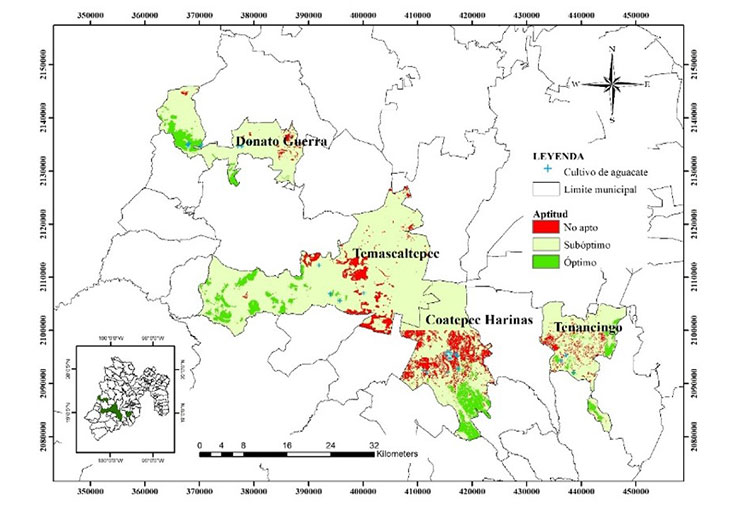
Spatial model of potential areas for avocado plantations in the State of Mexico
DOI:
https://doi.org/10.29312/remexca.v15i5.3515Keywords:
agronomic potential, avocado crops, multivariate GIS analysisAbstract
Abstract
In recent years, avocado has become one of the most important and demanded crops internationally, Mexico has 30% of the world’s production and the State of Mexico is the third producer nationwide, a situation that favors the excessive expansion of this crop in the state. For this reason, this research aimed to identify regions with optimal and suboptimal potential for the establishment of avocado plantations in the municipalities of: Coatepec Harinas, Donato Guerra, Temascaltepec and Tenancingo in the State of Mexico. The study was carried out in three stages, the integration of a geospatial database in the environment of geographic information systems, the construction of criteria for the analysis and weighting of territorial variables, and the development and validation of a potential allocation model for avocado crops. As a result, the areas that showed optimal potential represent a total of 9 543.82 ha, located south of the municipalities, distributed as follows: 3 261.2 ha in Coatepec Harinas, 2 973.87 ha in Temascaltepec, 2 124.41 ha in Donato Guerra, and 1 184.33 ha in Tenancingo. The areas with suboptimal potential represent a total of 6 098.54 ha, of which Coatepec Harinas has 2 183.63 ha, Temascaltepec 1 846.41 ha, Donato Guerra 1 326.34 ha, and Tenancingo 742.16 ha. The high potential of the different municipalities of the State of Mexico does not indicate that the entire area has the right conditions for the establishment of avocado crops.
Downloads
References
Atlas de Riesgos Ante el Cambio Climático en el Estado de México. 2023. http://ieecc.edomex.gob.mx/altas-riesgos.
El Financiero. 2019. Edomex buscará tener primera planta certificada de aguacate. https://www.elfinanciero.com.mx/nacional/edomex-buscara-tener-primeraplantacertificada-de-aguacate.
European Space Agency. 2022. ESA. El programa Copérnico. http://www.esa.int/esl/ESA-in-your-country/Spain/El-programa-Copernico.
INEGI. 2020. Instituto Nacional de Estadística y Geografía. Biblioteca digital de mapas. https://www.inegi.org.mx/app/mapas/.
INIFAP. 2012. Instituto Nacional de Investigaciones forestales, Agrícolas y Pecuarias. Determinación del potencial productivo en cultivos prioritarios en el Estado de México. Zinacantepec, Estado de México.
INIFAP. 2012b. Instituto Nacional de Investigaciones Forestales, Agrícolas y Pecuarias. Determinación del potencial productivo en cultivos prioritarios en el Estado de México. Zinacantepec, México. https://isbn.cloud/9786074259476/determinacion-del-potencial-productivo-en-cultivos-prioritarios-en-el-estado-de-mexico/.
Kauth, R. J. and Thomas, G. S. 1976. The Tasselled Cap-A Graphic Description of the Spectral-Temporal Development of Agricultural Crops as Seen by LANDSAT. LARS Symposia. 159 p.
Reyes, A. J. C.; Monteagudo, R. O.; Valdez, P. M. E.; Mejía, C. J.; Espíndola, B. M. y Urbina, S. E. 2017. Modelo fenológico para el aguacate “Hass” en el Estado de México. Memorias del V congreso latinoamericano del aguacate. Jalisco, México. 302-308 pp.
Ruiz, C. J. A. 1999. Determinación del potencial productivo de la costa sur de Jalisco. Estudio piloto. Informe de investigación INIFAP-Campo Experimental Centro de Jalisco.
SENASICA. 2022. Servicio Nacional de Sanidad, Inocuidad y Calidad Agroalimentaria. Impacto económico potencial de Xyleborus glabratus - Raffaelea lauricola en el cultivo de aguacate, en el estado de Michoacán, México. https://dj.senasica.gob.mx/Contenido/files/2022/septiembre/Impactoecon%C3%B3micopotencialdeXyleborusglabratusRaffaelealauricolaenelcultivodeaguacate,enelEstadodeMichoac%C3%A1n-4effcb0b-2b30-4ad2 abce-38360657eee5.pdf.
SIAP. 2023. Servicio de Información Agroalimentaria y Pesquera. http://www.siap.gob.mx/.

Published
How to Cite
Issue
Section
License
Copyright (c) 2024 Revista Mexicana de Ciencias Agrícolas

This work is licensed under a Creative Commons Attribution-NonCommercial 4.0 International License.
The authors who publish in Revista Mexicana de Ciencias Agrícolas accept the following conditions:
In accordance with copyright laws, Revista Mexicana de Ciencias Agrícolas recognizes and respects the authors’ moral right and ownership of property rights which will be transferred to the journal for dissemination in open access. Invariably, all the authors have to sign a letter of transfer of property rights and of originality of the article to Instituto Nacional de Investigaciones Forestales, Agrícolas y Pecuarias (INIFAP) [National Institute of Forestry, Agricultural and Livestock Research]. The author(s) must pay a fee for the reception of articles before proceeding to editorial review.
All the texts published by Revista Mexicana de Ciencias Agrícolas —with no exception— are distributed under a Creative Commons License Attribution-NonCommercial 4.0 International (CC BY-NC 4.0), which allows third parties to use the publication as long as the work’s authorship and its first publication in this journal are mentioned.
The author(s) can enter into independent and additional contractual agreements for the nonexclusive distribution of the version of the article published in Revista Mexicana de Ciencias Agrícolas (for example include it into an institutional repository or publish it in a book) as long as it is clearly and explicitly indicated that the work was published for the first time in Revista Mexicana de Ciencias Agrícolas.
For all the above, the authors shall send the Letter-transfer of Property Rights for the first publication duly filled in and signed by the author(s). This form must be sent as a PDF file to: revista_atm@yahoo.com.mx; cienciasagricola@inifap.gob.mx; remexca2017@gmail.
This work is licensed under a Creative Commons Attribution-Noncommercial 4.0 International license.


