
Balance hídrico en cuencas hidrológicas. Una aplicación basada en Google Earth Engine
DOI:
https://doi.org/10.29312/remexca.v17i1.3890Palabras clave:
agua, cuencas, decisiones, modeloResumen
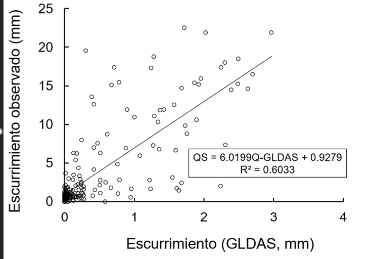
Dentro del proceso de toma de decisiones en cuencas, el balance hídrico requiere de información fácilmente disponible, así como de herramientas de decisión para acelerar los cursos de acción. El punto racional de partida en cuencas es el balance hídrico ya que éste cuantifica la potencialidad de la cuenca para producir escurrimiento. La mayoría de la información climática e hidrológica está dispersa y en muchos formatos lo que dificulta el proceso de análisis del balance hídrico y lo hace más lento. El presente código, escrito en JavaScript fue desarrollado durante 2024-2025, en el contexto de un proyecto fiscal de Instituto Nacional de Investigaciones Forestales, Agrícolas y Pecuarias. El ACUAC, está diseñado para su uso en la plataforma Google Earth Engine enfocado en el análisis hidrológico usando varias fuentes de datos. Permite al usuario visualizar y calcular el balance de agua en la cuenca seleccionada basándose en la precipitación, evapotranspiración y datos de escurrimiento. Los resultados se presentan en forma de gráficos y tablas mismos que pueden descargarse o editarse. La interfaz amigable lo hace fácil de usar además de que es muy intuitivo.
Descargas
Citas
Allan, J. A. 2000. Virtual water: A strategic resource in international food policy and water policy. International Journal of Water Resources Development. 15(1):61-75.
Allen, R. G.; Pereira, L. S.; Raes, D. and Smith, M. 1998. Crop evapotranspiration: Guidelines for computing crop water requirements FAO Irrigation and Drainage Paper No. 56. Food and Agriculture Organization of the United Nations (FAO). 3-13 pp. http://www.fao.org/3/X0490E/x0490e00.html.
CNA. 2021. Estadísticas del agua en México. 42-52 pp. https://files.conagua.gob.mx/conagua/publicaciones/Publicaciones/EAM%202021.pdf.
Delgado, B. J.; Arredondo, J. T.; Loescher, H. W.; Pineda-Martínez, L. F.; Carbajal, J. N.; and Vargas, R. 2019. Seasonal precipitation legacy effects determine the carbon balance of a semiarid grassland. Journal of Geophysical Research: biogeosciences. 124(4):987-1000. https://doi.org/10.1029/2018JG004799.
García-Codron, J. C.; Diego-Liaño, C.; Fdez-Arróyabe, H. P.; Garmendia-Pedraja, C. y Rasilla Álvarez, D. 2004. El clima entre el mar y la montaña. Asociación Española de Climatología y Universidad de Cantabria. 619-628 pp.
Gleick, P. H. 2014. Water security: The water-food-energy-climate nexus. Science. 345(6198):318-322. https://doi.org/10.1126/science.1258852.
Gorelick, N.; Hancher, M.; Dixon, M.; Ilyushchenko, S.; Thau, D. and Moore, R. 2017. Google earth engine: planetary-scale geospatial analysis for everyone. Remote Sensing of Environment. 202(1):18-27. https://doi.org/10.1016/j.rse.2017.06.031.
Hao, Z.; Chen, X. and Zhang, X. 2021. Satellite-based hydrological modeling and water resource management. Remote Sensing. 13(12):2423. https://doi.org/10.3390/rs13122423.
Jiménez-Jiménez, S.; Marcial, P. M. J.; Ojeda, B. W.; Sifuentes, B. E.; Inzunza, M. A. and Sanchez, C. I. 2022. VICAL: global calculator to estimate vegetation indices for agricultural areas with landsat and sentinel-2 Data. Agronomy. 12(7):1518. Doi:10.3390/agronomy12071518.
Kalnay, E. 2003. Atmospheric modeling, data assimilation and predictability. Cambridge University Press. 150-170 pp. https://assets.cambridge.org/97805217/96293/frontmatter/9780521796293-frontmatter.pdf.
Li, Y.; Wang, Z. and Zhang, L. 2022. Impact of terrain and land use on hydrological modeling accuracy in large basins using satellite-derived data. Journal of Hydrology, 599:126306. https://doi.org/10.1016/j.jhydrol.2021.126306.
Lijuan, C.; Yong, Z. and Ying, S. 2011. Climate change effect on hydrological processes over the Yangtze River basin. Quaternary International. 244(2):202-210 https://doi.org/10.1016/j.quaint.2011.01.004.
Perilla, G. A. and Mas, J. F. 2020. Google Earth Engine (GEE): una poderosa herramienta que vincula el potencial de los datos masivos y la eficacia del procesamiento en la nube. Investigaciones Geográficas, (101). https://doi.org/10.14350/rig.59929.
Quintana-Molina, J. R.; Sánchez-Cohen, I.; Jiménez-Jiménez, S. I.; Marcial-Pablo, M. J.; Trejo-Calzada, R. and Quintana-Molina, E. 2023. Calibration of volumetric soil moisture using Landsat-8 and Sentinel-2 satellite imagery by Google Earth Engine. Revista de Teledetección. 62:21-38. https://doi.org/10.4995/raet.2023.19368.
Real, R. and Vargas, J. M. 1996. The probabilistic basis of Jaccard’s index of similarity. Systematic Biology. 45(3):380-385. https://doi.org/10.1093/sysbio/45.3.380.
Reyes, J.; Pérez, M. y Rodríguez, L. 2019. Modelamiento de evapotranspiración en cultivo utilizando índices de vegetación obtenidos con sensores remotos Sentinel-2: Caso de estudio desarrollado en CENICAÑA 2019-2020. 83 p.
Rodell, M.; Velicogna, I. and Famiglietti, J. S. 2018. Satellite-based estimates of groundwater depletion in India. Nature. 460(7258):999-1002. https://doi.org/10.1038/nature08238.
Rodell, M.; Houser, P. R.; Jambor, U.; Gottschalck, J.; Mitchell, K.; Arsenault, K. and Lohmann, D. 2004. The global land data assimilation system. Bulletin of the American Meteorological Society. 85(3):381-394.
Schroeder, W.; Sulla-Menashe, D. and Giglio, L. 2014. The MODIS active fire detection algorithm and data products: an overview. Remote Sensing of Environment. 178(216):370-380. https://doi.org/10.1016/j.rse.2013.07.028.
United Nations. 2020. The United Nations world water development report. Water and climate change. UNESCO. 79-94 pp. https://unesdoc.unesco.org/ark:/48223/pf0000372983.
Velásquez-Valle, M. A.; Sánchez-Cohen, I. and Hawkins, R. H. 2017. Rainfall runoff relationships in a semiarid rangeland watershed in central Mexico based on the CN-NRCS approach. Model. Earth Syst. Environ. 3(2):1263-1272. https://doi.org/10.1007/s40808-017-0379-8.
Zhang, L.; Tian, J. and He, H. 2015. Evaluation of water use efficiency derived from MODIS products against eddy variance measurements in China. Remote Sensing. 7(9):11183-11201.
Zhao, F.; Tang, Q.; Liu, X. and Zhang, X. 2015. Assessing the performance of remotely sensed precipitation and GLDAS hydrological variables in streamflow simulation in the Huaihe river basin, China. Hydrology and Earth System Sciences. 19(5):2201-2213. https://doi.org/10.5194/hess-19-2201-2015.
Zhang, L.; Liu, D. and Zhou, Y. 2020. Evaluation of remote sensing-based precipitation datasets for hydrological applications. Journal of Hydrometeorology. 21(4):919-934. https://doi.org/10.1175/JHM-D-19-0120.1.
Descargas
Publicado
Cómo citar
Número
Sección
Licencia
Derechos de autor 2026 Revista Mexicana de Ciencias Agrícolas

Esta obra está bajo una licencia internacional Creative Commons Atribución-NoComercial 4.0.
Los autores(as) que publiquen en Revista Mexicana de Ciencias Agrícolas aceptan las siguientes condiciones:
De acuerdo con la legislación de derechos de autor, Revista Mexicana de Ciencias Agrícolas reconoce y respeta el derecho moral de los autores(as), así como la titularidad del derecho patrimonial, el cual será cedido a la revista para su difusión en acceso abierto.
Los autores(as) deben de pagar una cuota por recepción de artículos antes de pasar por dictamen editorial. En caso de que la colaboración sea aceptada, el autor debe de parar la traducción de su texto al inglés.
Todos los textos publicados por Revista Mexicana de Ciencias Agrícolas -sin excepción- se distribuyen amparados bajo la licencia Creative Commons 4.0 atribución-no comercial (CC BY-NC 4.0 internacional), que permite a terceros utilizar lo publicado siempre que mencionen la autoría del trabajo y a la primera publicación en esta revista.
Los autores/as pueden realizar otros acuerdos contractuales independientes y adicionales para la distribución no exclusiva de la versión del artículo publicado en Revista Mexicana de Ciencias Agrícolas (por ejemplo incluirlo en un repositorio institucional o darlo a conocer en otros medios en papel o electrónicos) siempre que indique clara y explícitamente que el trabajo se publicó por primera vez en Revista Mexicana de Ciencias Agrícolas.
Para todo lo anterior, los autores(as) deben remitir el formato de carta-cesión de la propiedad de los derechos de la primera publicación debidamente requisitado y firmado por los autores(as). Este formato debe ser remitido en archivo PDF al correo: revista_atm@yahoo.com.mx; revistaagricola@inifap.gob.mx.
Esta obra está bajo una licencia de Creative Commons Reconocimiento-No Comercial 4.0 Internacional.

