elocation-id: elocation-id: e4205
This study aimed to quantify and analyze the effects of the growth in the area cultivated with blue agave on deforestation, changes in cropping patterns, and soil erosion in Autlán de Navarro, Jalisco. Over the past 20 years, this crop has expanded intensively, driven by demand from the tequila industry and rising prices for a kilogram of agave hearts (from $21.00 to $30.00 pesos between 2021 and 2024). Through a census of plots, blue agave plantations belonging to tequila-producing companies and farmers were compared, recording changes in cropping patterns and deforestation, mainly of low deciduous tropical forest, as well as the presence of weeds, diseases and signs of soil erosion (visual evaluation). Results showed a deforestation rate of 39.7%; the conversion of cropping patterns represented 82%; 73% of plots received herbicides; 60% showed diseases treated with insecticides such as imidacloprid; and 90% showed moderate to severe erosion. Significant differences (p= 0.05) were observed in management between companies and farmers. It is concluded that the expansion of blue agave has led to changes in cropping patterns (from vegetables, corn and pastures to blue agave) and to deforestation, which responds to market volatility and a lack of contracts for the sale of the plantation.
Agave tequilana Weber., soil erosion, tequila regulatory council.
Deforestation is a process that involves converting forests into pastures or agricultural land ( Gómez-Pompa and Burley, 1991 ; Camacho-Sanabria et al ., 2015 ; Aghsaei et al ., 2020 ), which causes increased surface runoff and sediment production ( Demissie, 2022 ), destroys habitats and threatens endemic species ( Aka et al ., 2022 ). At the international level, Mexico leads in the deforestation of rainforests and mountain forests ( CONAFOR, 2020a ; CCMSS, 2024 ).
The state of Jalisco is an example where land clearing is carried out for conventional agriculture ( CONAFOR, 2020b ), specifically to establish extensive blue agave plantations since 1996 ( Vélez et al ., 1996 ) or to seek new areas with different climates for this purpose ( CRT, 2000 ). This transforms agroecosystems and alters cropping patterns ( Ruíz et al ., 2002 ; Valenzuela and Gaytán, 2009 ). For the state of Jalisco, this activity is enhanced by the tequila designation of origin (DOT, by its Spanish acronym), the certification of plantations, the international demand for tequila, and the establishment of new companies ( CRT, 2000 ).
In the Sierra de Amula region in Jalisco, blue agave emerged as an economic alternative in the early 1990s, with accelerated growth among private plot owners and plot leasing ( Gerritsen et al ., 2011 ). Leasing encourages monoculture and reduces sustainable practices ( Herrera-Pérez et al ., 2018 ), in contrast to the conventional management system ( Herrera-Pérez et al ., 2017 ).
The objective is to quantify and analyze the impact of the growth of the blue agave area, projected on the management of plots by companies and farmers, a driver of deforestation, changes in cropping patterns and soil degradation.
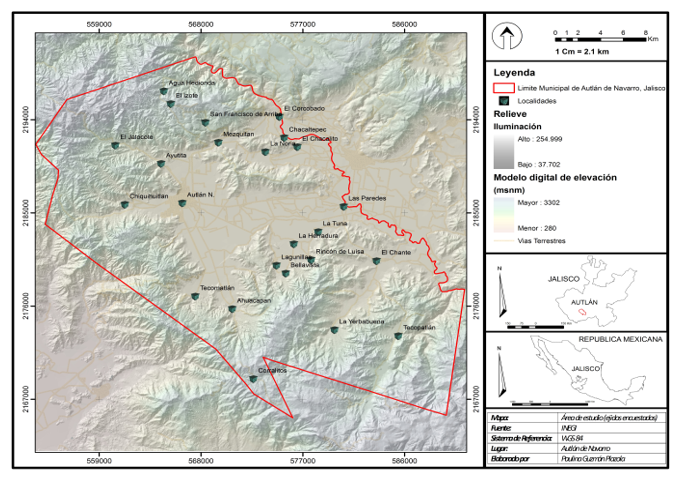
The study was conducted in the municipality of Autlán de Navarro, Jalisco, located in the Sierra de Amula region between coordinates 19° 34’ 30” to 19° 53’ 45” north and 104° 07’ 00” to 104° 27’ 35” west ( Figure 1 ), with an area of 962.9 km2and an altitudinal range above sea level of 900 to 2 700 m.
The blue agave area in the municipality of Autlán de Navarro was identified through georeferenced sampling of each plot in 2023 and through historical records from SIAP-SADER, the tequila regulatory council (CRT) by its Spanish initialism and the municipalities.
It was projected on Geographic Information Systems (GIS) by overlapping the plots in the supervised classification of the VI series land use images (INEGI, 2017) to identify changes in cropping patterns, deforestation and slope ranges by creating digital elevation models from covers with Shape vector format, supported by Excel and Arc-View v.3.1, and digitized in Arc-Info v.3.1 and Idrisi v.3.2. for Windows and Surfer v.8 ( Eastman, 1992 ), at a resolution of 20 m x 20 m.
The soil type was identified based on a soil map (INEGI, 1976). To estimate the changes in cropping patterns and deforestation, the following formula was used:
T= rate of change in cropping patterns and deforestation (%); lnA= area of the current year (ha); lnB= area of the previous year (ha); n= difference in years between A and B.
During the census of blue agave plots, those managed by tequila-producing companies and farmers were identified and visually compared, considering the level of erosion in the following categories: mild (not visible), moderate (laminar erosion and sediment accumulation in the lower parts) and severe (gully formation).
The presence or absence of weeds was identified, and diseases (damage) and pests (detection of adults, larvae, active galleries, exudates, or fresh damage to the base or bud) were identified through random sampling ( Arista-Carmona et al ., 2023 ). Likewise, cultural practices (weeding and sucker removal) and use of machinery were determined. A chi-square test and Tukey mean separations with α= 0.05 were applied, using SAS v.9.4.
Based on the records of SIAP-SADER and CRT, the registered area of blue agave in the DOT region was 210 000 ha (73% in Jalisco) in 2021, increasing to 413 870 ha in 2023.
In the Sierra de Amula region, where the municipality of Autlán de Navarro is located, the increase in blue agave plantations since 1996 was due to the payment offered per kilogram of agave hearts, $17.00 pesos in local currency, which encouraged farmers to plant extensively independently, but with a lack of knowledge of agronomic management ( Guevara et al ., 2024 ) or to lease their plots for this purpose. Herrera-Pérez et al . (2018) identify that leasing encourages monocultures with unsustainable practices, a management condition that Moreno-Hernández et al . (2011) identified for the Sierra de Amula region. Based on historical data from SIAP-SADER, the growth of the planted area was estimated at an average rate of 18%.
The blue agave area reported by SIAP-SADER (2020) in the Sierra de Amula region exceeded 40 000 ha in 2019. The purchase price of agave hearts fluctuated around $30.00 pesos kg-1between 2021 and 2024, then decreased to between $3.00 and $5.00 pesos at the end of 2024. Based on historical data from SIAP-SADER, blue agave in Autlán de Navarro is one of the five base crops for economic development, with growth rates of up to 48% according to the industrial price ( Figure 2 ).
Due to the absence of contracts for the purchase and sale of blue agave production by farmers or the lack of their registration with the CRT, the area they planted was not included in the official records before the Rural Development Support Center (CADER-SADER) by its Spanish acronym, unlike the area managed by the companies.
This situation may generate discrepancies between the area reported in this research and the official data. Due to the extensive establishment of blue agave plantations in Autlán de Navarro, there is a recognized lack of planning for their establishment ( Guevara et al ., 2024 ).
From the database generated, it is recognized that the blue agave plantations in the municipality were established on various soil types, mainly Phaeozem (63.4%), Vertisols (21%) and Regosols (11.34%), and under heterogeneous topographic conditions (plains or slopes). More than 50% of plots combine two or more slope ranges, mainly 0 to 5% (corresponding to open areas), which translates into a shift in cropping patterns from vegetables, corn or pastures to blue agave ( Figure 3 ); the rest are established on slopes >10% ( Table 1 ). When superimposed on land-use and land-cover images, this information primarily reflects the deforestation of low deciduous tropical forests (LDTFs).
This has led to eroded soils by modifying their hydraulic properties ( Tena et al ., 2019 ; Aghsaei et al ., 2020 ), as well as to habitat fragmentation ( Bogaert et al ., 2008 ). The estimated rate of change in cropping patterns toward blue agave plantations was 42.4%, considering open areas with a slope range of 0 to 5%, LDTP deforestation of 39.7% and urban areas of 1.4% ( Figure 4 ).
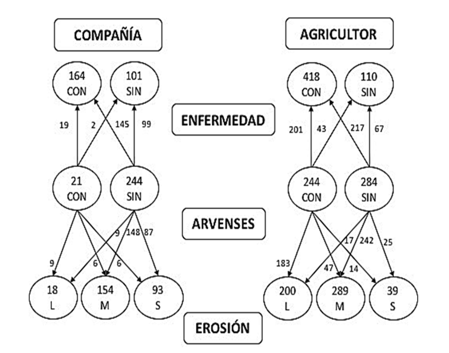
Of the 793 sampled plots, 265 were managed by companies, characterized by the absence of weeds in 93.5% of cases, a condition that increased soil erodibility, registering 18 plots with mild erosion (68.33 ha), 154 with moderate erosion (653.53 ha) and 93 with strong erosion (356.08 ha), the latter in the harvesting stage. Of the 528 plots managed by farmers, 54% did not present weeds, indicating greater use of herbicides; 200 presented mild erosion (479.5 ha); 289 had moderate erosion (664.97 ha) and 39 showed strong erosion (140.73 ha) ( Figure 5 ).
Guevara et al . (2024) ; García-Montoya et al . (2021) recognize that the process of deforestation and changes in cropping patterns increase surface runoff and soil loss.
The phytosanitary conditions of the plots showed leaf spot ( Botryodiplodia sp. Theiss. and H. Syd), root rot ( Fusarium oxysporum Schltdl), and black spot ( Rhizoctonia solani Kühn) in 62% of companies’ plots and 79% of farmers’ plots. The density of the agave weevil ( Scyphophorus acupunctatus Gyllenhal) did not exceed 15% per plot.
The results indicate that the plantations present heterogeneous management conditions ( Table 2 ), reflecting the absence of unified sustainability criteria, such as the establishment of contour furrows, despite the internationally recognized certification of the blue agave crop and the CRT, the most important agricultural, cultural and economic emblem of Mexico.
Regarding the use of herbicides, there were significant differences (p< 0.05) between plots managed by companies and those managed by farmers. Farmers’ plots have a balanced distribution (54% use herbicides and 46% do not), unlike companies’ plots, which show a marked preference for using herbicides, with 94%.
The chi-square test confirmed differences (χ²= 115.4, df= 1, p< 0.001). However, there is similarity in degradation and phytosanitary problems across groups, without considering ejido boundaries ( Table 3 ).
| Comparison | Difference in medians | q | Adjusted p-value | Significant (α= 0.05) |
|---|---|---|---|---|
| Moderate vs Mild | 100 | 5.056 | 0.012 | Yes |
| Strong vs Mild | 4 | 3.528 | 0.089 | - |
| Moderate vs Strong | 6 | 2.45 | 0.21 | No |
The post-hoc test (Tukey) showed significant differences only between moderate and mild erosion (difference in medians= 10.0; p= 0.012). No significant differences were found between strong and mild (p= 0.089) or between moderate and strong (p= 0.21) ( Table 3 ).
On the other hand, the chi-square test indicated a significant association between producer type and erosion level (χ²= 78.21; df= 2; p< 0.001). Chuma et al . (2021) reported that changes in cropping patterns cause high linear rates of soil erosion.
In this sense, the use of herbicides (glyphosate, paraquat, hexazinone, and diuron) showed a strong association with soil degradation (χ²= 210.34; df= 2; p< 0.001), particularly in plots without weeds and with moderate erosion, which shows that eliminating vegetation cover is a determining factor in the process.
Sixty percent of the sampled area (617 plots, equivalent to 1 720.79 ha) had a crop age range of 3 to 4 years. This figure underscores the need to plan the renewal of plantations to reduce peaks in supply and demand, as a measure of market stabilization, based on principles of agricultural economics ( FAO, 2018 ).
This condition is particularly critical for independent farmers, since 88% of their plots are concentrated in this range, and they report marketing difficulties due to the absence of purchase contracts or guaranteed prices, which has led to the abandonment of their plots. This trend suggests that farmers’ plantations were established out of economic necessity and by imitating the companies’ production models.
This problem observed in Autlán de Navarro is consistent with what was reported by Quesada-Román and Díaz-Bolaños (2019) , who recognize that landscape modification by agricultural activities, combined with poor management of environmental policies, promotes high rates of deforestation. Amid the disorderly expansion of blue agave in the DOT region, without territorial planning or consideration of land-use capacity, this situation has generated environmental impacts that compromise the sustainability of the tequila industry ( Guevara-Gutiérrez et al ., 2024 ).
Furthermore, the absence of effective government regulation, the lack of correspondence between certification, the CRT, and the absence of sustainable practices perpetuates this extensive and degrading model.
The expansion of blue agave in Autlán de Navarro was associated with changes in cropping patterns and the deforestation of low deciduous tropical forest.
Differences in management were observed between companies and farmers. Companies prioritize chemical control, which is linked to higher levels of soil erosion. Farmers apply herbicides more moderately and have a higher proportion of plots with mild erosion.
The elimination of vegetation cover (weeds) with herbicides was associated with soil degradation, particularly in plots with moderate erosion.
Based on these results, it is recommended that future studies evaluate the relationships among management practices, erosion and deforestation, as well as the design of differentiated strategies by producer type.
Aghsaei, H.; Mobarghaee, D. N.; Moridi, A.; Asadolahi, Z.; Delavar, M.; Fohrer, N. and Wagner, P. D. 2020. Effects of dynamic land use/land cover change on water resources and sediment yield in the Anzali wetland catchment, Gilan, Iran. Países Bajos. Science of the Total Environment. 712:136449. https://doi.org/10.1016/j.scitotenv.2019.136449.
Aka, K. S. R.; Dibi, H. N.; Koffi, J. N. and Bohoussou, C. N. 2022. Land cover dynamics and assessment of the impacts of agricultural pressures on wetlands based on earth observation data: case of the Azagny Ramsar site in Southern Côte d’Ivoire. Estados Unidos de América. Journal of Geoscience and Environment Protection. 10(5):43-61. https://doi.org/10.4236/gep.2022.105004.
Arista-Carmona, E.; González-Hernández, H.; Rodríguez-de la O, J. L. y Cibrián-Tovar, J. 2023. Incidencia, fluctuación poblacional y porcentaje de severidad de Scyphophorus acupunctatus en maguey pulquero en el noreste del Estado de México. Revista Fitotecnia Mexicana. 46(2):157-166. https://doi.org/10.35196/rfm.2023.2.157.
Bogaert, J.; Bamba, I.; Koffi, K. J.; Sibomana, S.; Djibu, J. K.; Champluvier, D. and Visser, M. N. 2008. Fragmentation of forest landscapes in Central Africa: causes, consequences and management. In: patterns and processes in forest landscapes: multiple use and sustainable management. Lafortezza, R.; Sanesi, G.; Chen, J. and Thomas, R. (Eds.). Estados Unidos de América. Springer. 67-68 pp.
Chuma, G. B.; Mondo, J. M.; Ndeko, A. B.; Mugumaarhahama, B. E. M.; Blaise, M.; Valérie, M.; Jacques, K.; Karume, K. and Mushagalusa, G. N. 2021. Forest cover affects gully expansion at the tropical watershed scale: case study of Luzinzi in Eastern DR Congo. Paises Bajos. Trees, Forests and People. 4:100083. https://doi.org/10.1016/j.tfp.2021.100083.
Guevara, G. R. D.; Olguín, L. J. L.; Mancilla, V. O. R.; Rosales, A. M. P.; Barreto, G. O. A.; Palomera, C. y Avelar, R. J. U. 2024a. Prácticas sustentables, alternativas para la conservación del suelo en Agave tequilana Weber. México. Nova Scientia. 16(32):1-15. https://doi.org/10.21640/ns.v16i32.3450.
Guevara-Gutiérrez, R. D.; Palomera-García, C.; Olguin-López, J. L.; Mancilla-Villa, O. R.; Rosales-Almendra, M. P. and Barreto-García, O. A. 2024b. Effect of blue agave (Agave tequilana Weber.) management on soil erosion. Estados Unidos de América. Air, Soil and Water Research. 17:1-10. https://doi.org/10.1177/11786221241236632.
Herrera-Pérez, L.; Valtierra-Pacheco, E.; Ocampo-Fletes, I.; Tornero-Campante, M. A.; Hernández-Plascencia, J. A. y Rodríguez-Macías, R. 2017. Prácticas agroecológicas en Agave tequilana Weber bajo dos sistemas de cultivo en Tequila, Jalisco. México. Revista Mexicana de Ciencias Agrícolas. 18(esp):3711-3724.
Herrera-Pérez, L.; Valtierra-Pacheco, E.; Ocampo-Fletes, I.; Tornero-Campante, M. A.; Hernández-Plascencia, J. A. y Rodríguez-Macías, R. 2018. Esquemas de contratos agrícolas para la producción de Agave tequilana Weber en la región de Tequila, Jalisco. México. Agricultura, Sociedad y Desarrollo. 15(4):619-637.
Moreno-Hernández, A.; Estrella-Chulim, N.; Escobedo-Garrido, S.; Bustamante-González, A. y Gerritsen, P. W. 2011. Prácticas de manejo agronómico para la sustentabilidad: características y medición en Agave tequilana Weber en la región Sierra de Amula, Jalisco. México. Tropical and Subtropical Agroecosystems. 15(4):159-169.