elocation-id: e4249
The research was conducted during 2022 and 2023 in the northern region of the municipality of Salamanca, Guanajuato, in the localities (Los Hernández, Los Razos de Ancón, Los Cenizos and La Compañía) corresponding to the semi-arid zone, where production systems are highly vulnerable to accidents, mainly due to water scarcity. In order to know their complexity and propose alternatives for improvement, a diagnosis of the production systems was carried out. The methodology used was the agrarian diagnosis, and the tools employed to obtain the information were semi-structured interviews, geographic information systems, and the 2020 Population and Housing Census. The results showed three principal agroecosystems: irrigated agriculture (agricultural), rainfed agriculture (agrosilvopastoral), and rangeland (silvopastoral), as well as 10 cultivation or rearing systems. In order to understand their complexity and propose alternatives for improvement, a typology of production units was developed, identifying three categories that were very similar to one another yet distinct. To determine economic indicators, the methodology generated by Dufumier (1996) and Apollin and Eberhart (1999) was used, which aims to understand the functioning of production systems and their prospects of evolution. It was concluded that the stability and permanence of production units depend on the ways of using available resources, whereas their differentiation is a function of the availability of water, the degree of intensification of labor, the available surface area, and the use of technology.
agrarian diagnosis, agriculture in Guanajuato, agroforestry.
Semi-arid rainfed agriculture (SRA) in Guanajuato is subjected to a low productivity system because producers intend to imitate the adjacent intensive irrigation system even though their socioeconomic and physiographic conditions and the historical evolution of their production systems are very different; this has caused the SRA in this region to be seven times less profitable per unit of area than irrigated agriculture, to have from 10 to 50 times greater chances of loss, and to be two times less diverse.
Therefore, it is necessary to generate production options that help mitigate this disparity in yields, diversity and risk; however, it is required to have a methodology that is responsible for finding the articulating factors of changes in the modes of production, and the collection and analysis of data that theoretically support the dynamics of productive practices to make tangible -in a holistic way- the processes of formation, differentiation, existence and problems of agricultural systems within specific ecological and socioeconomic contexts (Cochet, 2016; Fare et al., 2017; Ramos et al., 2020; Nair et al., 2021).
In Mexico, there are records of the design and implementation of AFSs in semi-arid climates under the rainfed system, aimed at increasing production options and reducing the risk of total losses in the system. Hernández (2010) implemented a mesquite-maguey-oat-kochia system and demonstrated that, under rainfed conditions, it could generate a benefit-cost ratio (B/C) of 1.85. Osuna et al. (2019) developed a nopal-leucaena-milpa system to produce forage and food in the rainfed system of the Mexican highlands, along with micro water-harvesting techniques, with which they achieved yields six times higher than the traditional system. Ruiz (2020) implemented the mesquite-maguey-pasture system to have forage options in the Guanajuato rainfed agriculture and Sánchez et al. (2016) developed the kochia-mesquite system to produce forages in chemically degraded soils.
In this context, agroforestry systems (AFSs) are an option to reduce risk and increase the profitability of productive units (Mercer et al., 2014). The objective of this research is to develop a biophysical, socioeconomic, and historical diagnosis in localities to understand the biophysical and social environment in which they are located, to later categorize the production units in the semi-arid zone of the northern region of Salamanca, Guanajuato.
The methodology used for this research was the Agrarian Diagnosis, which analyzes the complexity of a situation present in a specific time and place. The methodology was applied to the Latin American environment by Apollin and Eberhart (1999). The northern Bajío of Salamanca, Guanajuato, was defined as the study area. The coordinates that delimit the study area are: to the south 20° 38’ 47.532” north latitude, to the north 20° 41’ 28.659” north latitude, to the east 101° 08’ 10.354” west longitude, and to the west 101° 09’ 49.400” west longitude.
The socioeconomic characterization was carried out using socioeconomic data obtained from the 2020 Population and Housing Census conducted by the National Institute of Geography, Statistics, and Informatics (INEGI, 2020). The biophysical characterization began with climatological data from the National Meteorological Service corresponding to climate normals for the state of Guanajuato; the data used were those from station 11041-Los Razos (SMN, 2023); the landscape reading was carried out through participatory tours.
Semi-structured interviews were conducted with farmers in order to learn about the four levels of complexity listed by FAO (1999), which are as follows: agroecosystem, production system, cultivation or rearing system, and technical itinerary. Once this information was collected, interviews were conducted with those farmers who were considered specialized to learn about the production systems and the technical itinerary of the cultivation and rearing systems, in order to understand the logical sequence of actions that are carried out, and the processes, inputs, and outputs of each of these systems.
The base information from the geoportal of the National Biodiversity Information System, the edaphological vector dataset series II, and land use and vegetation series VI of INEGI, the INEGI digital elevation model, and climatological information (ERIC III) were used. For the historical evolution of the production systems, elderly people and active farmers with many years in the area were defined as the informants, who were interviewed until reaching the saturation point (Morse, 1995). The information obtained was used to create a timeline divided into specific periods of change, identifying the articulating factors and the consequences that these had on the production systems.
For the qualitative definition of production unit categories, the producer panel or Delphi technique was used, which was developed by the American Agricultural Economics Association’s Task Force under three approaches: cash flow, financial analysis, and economic analysis. Sagarnaga et al. (2018) adapted the methodology to Mexico. The target population for the panels was selected through participatory tours and semi-structured interviews beforehand and productive flow diagrams were drawn up. During these meetings, the producers chose the factors of production (land, labor and capital) that best represented their common situation. In this way, the farmers themselves defined the category to which they belonged.
Finally, for the socioeconomic evaluation, the methodology used was developed by Dufumier (1996) and Apollin and Eberhart (1999) for the determination of indicators, identifying the agronomic logics of the different production units and their reason for being, depending on the agroecological and socioeconomic context of each category. The following economic indicators were determined: gross product (GP), intermediate consumption (IC), gross added value (GAV), economic depreciation (D), and net added value (NAV). The economic replacement threshold (R) was determined by the extreme income poverty line (EIPL), which is equivalent to the cost of the food basket, which was estimated at $1 666.91. The survival threshold (S) was determined by the income poverty line (IPL), which is equivalent to the annual cost of basic needs, which was estimated at $3 105.59 by April 2023 (CONEVAL, 2024).
As can be seen in Table 1, of the four communities, the inhabitants of La Compañía have the highest degree of education and the lowest percentage of unemployment, with a difference of 1.27 years and 4.7%, respectively. Los Cenizos reports the lowest percentage of men (43.8%) and the highest percentage of population over 60 years of age (20.1%).
The tours began on flat lands of El Bajío in Guanajuato belonging to the community of La Compañía, continued through rainfed ejido lands with slight slopes belonging to Los Razos de Ancón and Los Cenizos, then moved on to steep terrains with thin, stony, unproductive soils, and ended in the rangeland area of Los Hernández, which presents typical species of the Mexican dry forest and moderate use with grazing animals such as goats, sheep, and cattle. Figures 1 and 2 show the tours conducted with cooperating farmers, as well as the total km travelled and the altitudinal profile of both routes.
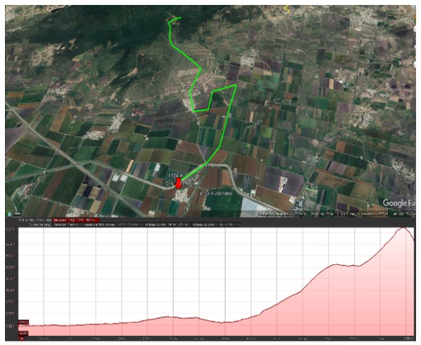
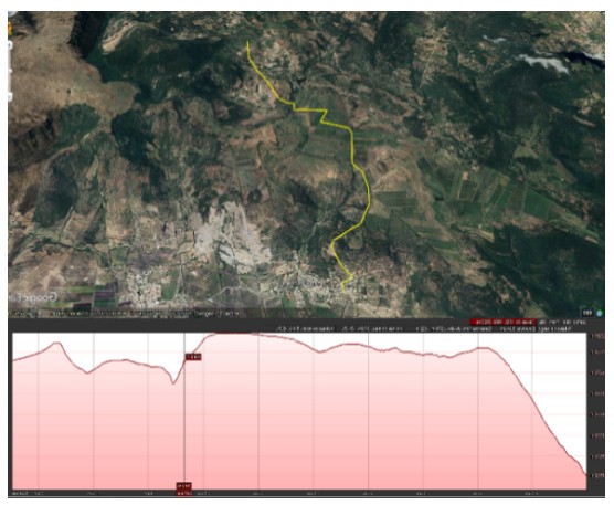
Of the 1 550.56 ha of the communities studied, 67% are flat or relatively flat lands that are mainly in the southern zone of the study area and correspond to El Bajío of Guanajuato, whereas 19.4% are in sloping terrains located in the central zone and in a small highland of the northern mountainous area. Thirteen point six percent are in moderately steep condition in the northern area of the study area.
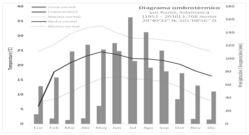
The average temperature calculated from climatological data from the National Meteorological Service, corresponding to climate normals for the state of Guanajuato, was 19.6 °C; for its calculation, the data corresponding to station 11041-Los Razos (SMN, 2023) were used. The accumulated annual precipitation is 658 mm. The total evaporation is 2 070 mm; through the ombrothermal diagram, it was found that the wet period runs from June to September, lasting 122 days and receiving 539 mm of precipitation. Table 2 and Figure 3 show the climatic parameters for the study area.
Forty-eight percent of the soils correspond to pellic Vertisol, being found in the southern area of Ejido Los Razos de Ancón, the whole area of La Compañía, and partially in Los Razos and Los Cenizos. The remaining 52% of the land has haplic Phaeozems, located in the central and northern zones of the study area, partially corresponding to the localities of Los Razos and Los Cenizos, and the whole of Los Hernández. Regarding land use, most of the area corresponds to irrigated agriculture and good rainfed agriculture, occupying 67.1% of the total area, and the remaining 33% corresponds to low-to-moderately steep slopes with secondary vegetation of Mexican dry forest.
Three agroecologically homogeneous zones (agroecosystems) were found: 1) flat lowlands with irrigated agriculture; 2) the hilly midlands, which are characterized by an agrosilvopastoral system with rainfed agriculture and semi-intensive livestock farming; and 3) the highlands with steeper slopes and a greater diversity of agrosilvopastoral and silvopastoral systems, with rainfed agriculture. The results of the landscape reading coincide with those reported by Uribe et al. (2021); Cruz and León (2010) describe three agroecologically homogeneous zones: a flat zone with irrigation and cultivation of cereals and vegetables, a zone with moderate slopes, rainfed agriculture, and animal grazing and finally, a silvopastoral zone of rangeland in hills.
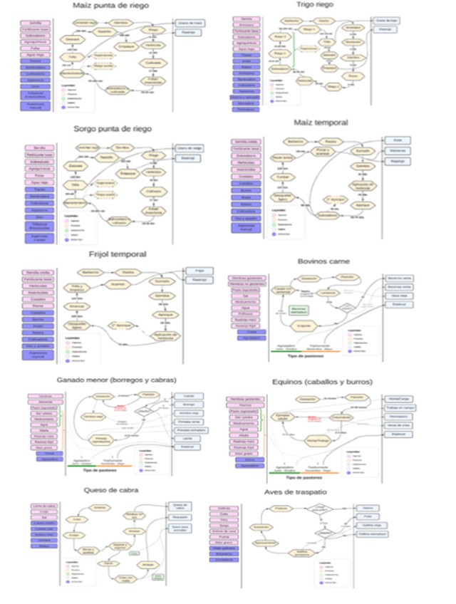
When systematizing the information obtained in the field, 10 production systems were found; Figure 4 shows the flow diagrams (inputs, process and outputs).
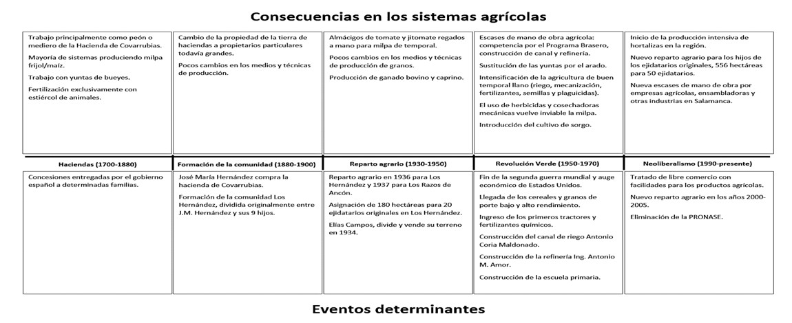
As can be seen in Figure 5, five relevant historical periods of significant change within the region were identified: the haciendas (1700-1880), the formation of the communities (1880-1900), agrarian distribution (1930-1950), the green revolution (1950-1970) and neoliberalism (1990-present).
Three categories of production units were identified; the cultivation and/or rearing systems used were determined, along with the economic parameters required to construct and analyze the corresponding economic indicators.
Technified business producers with an area of 8 ha, divided into 4 ha of irrigation and 4 ha of rainfed land, the destination of their production is the market. The soils are deep and highly productive. The company is managed directly by the producer. The family does not participate in work, and the children study or work in the city. Agricultural activities are carried out in spring-summer and autumn-winter. During the spring and summer, they sow corn or sorghum in the 4 ha of irrigated land and establish sorghum in the 4 ha of rainfed land. In the autumn-winter season, they grow wheat on the irrigated land.
Decapitalized producers with rainfed agricultural production systems and livestock production systems with minor species. With an agricultural area of 3 ha of rainfed land and 6 ha of rangeland. The soils are slightly stony with good depth. The system is managed by the producer and their family. Soil work, such as fallowing, harrowing and sowing, is carried out with other producers. They have a 100 m2 pen and a 36 m2 warehouse to store food, forage and tools. Their cattle herd consists of 20 sheep and 20 goats, which they use to produce and sell sheep, goats and cheese, respectively. The animals are grazed daily on the rangeland from June to November. In the dry season, they graze on the neighbors’ harvest residues, roadsides, and irrigation canals. This category grows 1 ha of maize, 1.5 ha of sorghum, and 0.5 ha of beans, all grown in spring-summer under rainfed conditions. Agricultural and livestock production is used for self-consumption and the sale of surpluses.
Decapitalized producers with rainfed agriculture and use of rangeland with minor species and cattle on communal lands, they have an area of 11 ha. They cultivate 1.75 ha of corn, 0.25 ha of beans and 9 ha of rangeland. The agricultural soils are shallow, with moderate to steep slopes, low fertility, and stony. The system is managed by the producer and their family; the destination of their production is self-consumption and sale of surpluses. They have a 200 m2 pen with a herd of 20 sheep, 15 goats, 7 breeding cows and 1 stud bull, which they use to produce sheep, kids, cheese, and calves for sale. Animals are grazed in the rangeland during the rainy season (June to November). During the dry season, the animals are taken to the community pens, where those with ideal weight are sold, and the smallest are kept with crop residues and purchased grain.
Table 3 summarizes the economic indicators obtained from the panels. An important source of income is animal production for categories II and III. Depreciation was low for all categories. These results are consistent with other diagnoses that assign fairly low amortizations for traditional production systems (Cruz et al., 2015; Uribe et al., 2021; DOF, 2021; Méndez, 2022).
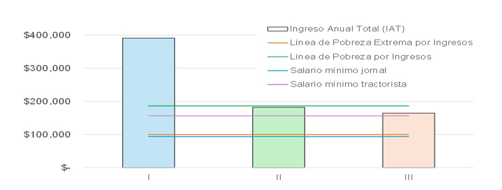
The most profitable product was irrigated corn with a NAV of $223 412.29. The number of workdays invested in the production units also varied significantly. For category I, it was 58.5 workdays, while for categories II and III, it was 210 and 266 workdays, respectively. When comparing the total annual income (TAI) with the annualized thresholds of economic replacement (R), survival (S) and minimum wage per workday (MWD), it was observed that the category I producer exceeds all the thresholds and is able to cover all the basic needs of the family, reproduce their means of production, and invest in their production unit.
On the other hand, categories II and III exceed the R threshold and the region’s minimum wage (MW) but do not exceed the IPL. This indicates that categories II and III are unable to meet the family’s needs fully and do not have the resources to reproduce their production unit. Table 4 and Figure 6 show the different levels of social reproduction by category.
The stability and permanence of production units depend on the forms of using the available resources, whereas their differentiation is a function of the availability of water, the degree of workforce intensification, the available surface area, and the use of technology. When the total annual income is equal to or less than the extreme income poverty line (EIPL), the production unit cannot meet the family’s needs or replace the means of production.
The category II and III production units, although they exceed the EIPL (R), have lower incomes than the IPL (S), yet they continue to exist, probably thanks to the sale of their labor outside the production unit (migration). The diagnostic analysis of the production units in the northern region of Salamanca, Guanajuato, allowed us to understand the complexity of the cultivation and rearing systems and the interactions between them.
By being able to understand this complexity, its historical origin, and the limiting biophysical and economic factors that determine producers’ decision-making, we will be able to design improvement strategies. In this sense, agroforestry is seen as one of the most appropriate options for the sustainable development of agricultural, livestock, and forestry systems.