elocation-id: e4065
The study analyzed the evolution of agricultural technology use in the Rural Development District 043, Durango, from 1991 to 2019 and its impact on productivity and agricultural area. Based on spatiotemporal analyses using GISs and descriptive statistics, there was a more than 50% increase in the technified area with irrigation between 1991 and 2007, which remains stable until 2021, and a greater use of chemical fertilizers and herbicides. These results show rural modernization processes and sustainability challenges.
agricultural landscape, agricultural technification, rural development district.
Agricultural landscapes, the result of the interaction of ecological and social factors, offer essential ecosystem services (raw materials and scenic beauty) (Kizos and Spilanis, 2004; Popa, 2014; Jones et al., 2016; Gaitán-Cremaschi et al., 2017; Yang et al., 2022). However, as dynamic systems influenced by policies, technological advances, and economic interests, they are exposed to environmental impacts that are difficult to foresee and to processes of social unsustainability (Gutiérrez-Yurrita, 2007; Molinero, 2013).
In Mexico, agricultural modernization has been promoted through public policy instruments, such as the creation of rural development districts (DDR, by its Spanish initialism) in 1988 and the Sustainable Rural Development Law (2001), to optimize resources and promote comprehensive rural development (DOF, 1987; DOF, 1988; DOF, 2021). Nevertheless, agricultural development has been uneven, as the north and center have more infrastructure and technology, while the south practices family farming with less access to resources and technical support (Hernández, 2014; Vázquez and Cruz, 2014; FAO, 2018).
This inequality is reflected in the Durango countryside, whose agriculture is represented by 60% of smallholding units (INEGI, 2016). On the other hand, national and regional agriculture faces challenges such as growing demand for food, land use change, climate change, and natural resource degradation, making it necessary for producers to balance productivity and sustainability through the use of innovative and affordable technologies (Aguilar and Ortiz, 2000; FAO, 2015).
Therefore, this work aimed to analyze the use of agricultural technologies over time and its impact on the productivity and agricultural area of DDR 043.
The study was conducted in the rural development district (DDR) 043, located in the south of the state of Durango, covering the municipalities of Canatlán, Durango, Mezquital, Nombre de Dios, Nuevo Ideal, Poanas, Súchil and Vicente Guerrero, which represents 22.01% of the state territory (≈27 134 km2).
A mixed exploratory-descriptive design was followed to analyze the changes in land use and vegetation during the 1997-2009 and 2009-2021 periods, through map algebra and Boolean aspects, with the ArcGIS and Idrisi Selva software and series I, IV, and VII of INEGI (scale 1:250 000), a reclassification of maps was carried out based on the proposal by Palacio-Prieto et al. (2004) to homogenize the information and subsequently perform a cross-tabulation between series.
Likewise, descriptive statistics from the Agricultural and Ejido Censuses (1991, 2007, 2022) were used to evaluate the evolution of the agricultural frontier relative to other land uses, technification, and regional production.
The land-use analysis shows that forests predominate in DDR 043; from 1997 to 2021, rainfed agriculture declined, and human settlements increased. Although most of the area remains conserved, irrigated agricultural land increased between 1997 and 2009 due to productive activities and changes in use. In that period, irrigated agriculture increased by 51 420.31 ha, whereas scrublands decreased by 119 976.56 ha and rainfed agriculture decreased by 9 368.75 ha (Table 1).
Between 1997 and 2009, the scrubland area was converted to areas for irrigated (0.21%) and rainfed agriculture (0.28%), and the grassland area was also converted to the same modalities (0.48% and 1.35%). Rainfed agriculture went to grassland (0.51%) and both types of agriculture to human settlements (0.15% and 0.17%). Also noteworthy were conversions from scrubland and grassland to forest (3.67% and 1.55%), from forest to jungle and grassland (1.43% and 2.76%), and from rainfed to irrigated agriculture (1.54%) (Table 2).
Regarding the 2009-2021 period, forests recorded the largest increase in area, with 32 523.4 ha, whereas grassland was the cover that decreased the most, losing 21 271 ha. Irrigated agriculture showed a notable growth of 4 493.75 ha, while rainfed agriculture fell by 12 692.19 ha (Table 3).
The largest trends of change observed were from grassland to forest (1.22%), from rainfed agriculture to grassland (0.44%), and from rainforest to forest (0.48%). On the other hand, the transformation from both irrigated and rainfed agriculture to human settlements was low, registering 0.08% and 0.05%, respectively. In addition, rainfed agriculture showed a trend of becoming irrigated agriculture of 0.16%. On the other hand, grassland presented probabilities of change to irrigated and rainfed agriculture, with values of 0.10% and 0.26%, respectively. Nonetheless, rainfed agriculture showed a greater propensity (0.44%) to be converted to grassland (Table 4).
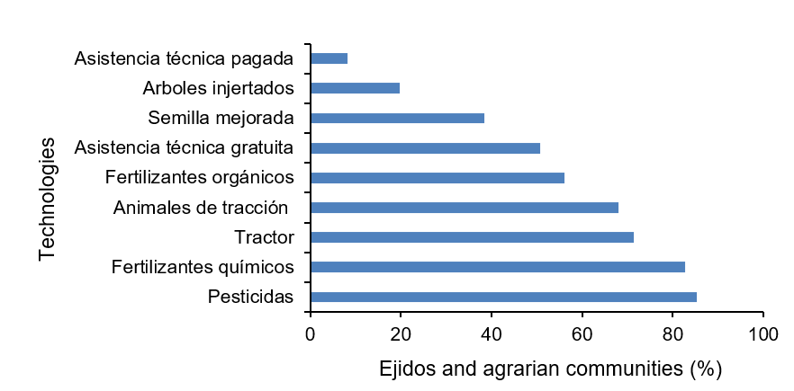
In 1991, INEGI collected information on 97% of the ejidos and agrarian communities in DDR 043 (n= 244). The most used technologies were pesticides (82%) and chemical fertilizers (82.7%), whereas paid technical assistance was used the least (8.2%) (Figure 1).
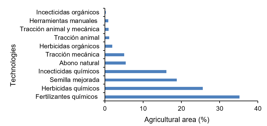
According to the 2007 Agricultural Census of INEGI, DDR 043 registered 269 723.3 hectares of agricultural land, of which 35.2% used fertilizers and 25.5% used chemical herbicides; in contrast, the use of organic insecticides (0.23%) and hand tools (0.86%) was limited (Figure 2).
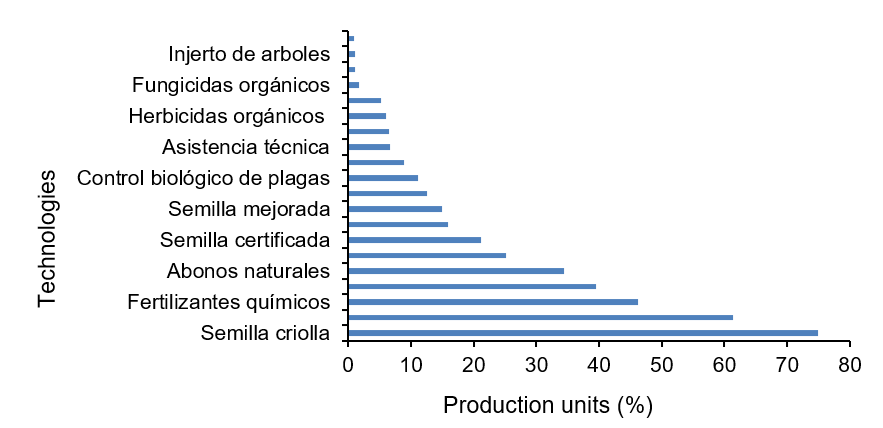
In 2021, INEGI reported 15 352 agricultural production units in DDR 043, mainly in Durango, Mezquital and Nuevo Ideal. Seventy-four-point nine percent used improved seed and 61.3% used herbicides. Transgenic seed and mulch were the least adopted technologies, present only in 0.88% and 1.06% of PUs, respectively. The 2021 census included other technologies such as biological control, fungicides, certified and transgenic seeds and crop rotation, among others (Figure 3).
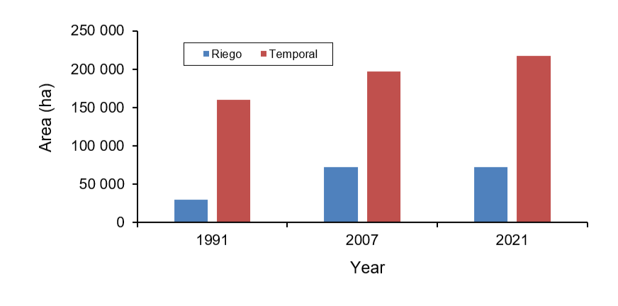
Because the 1991, 2007 and 2021 censuses used different measures, it was not possible to directly compare the use of agricultural technologies in DDR 043. In 1991, ejidos and communities were counted, whereas subsequent censuses recorded the planted area and production unit. The data show how the irrigated area has changed: although rainfed agriculture predominated and grew between 1991 and 2021, the area under irrigation increased by more than 50% between 1991 and 2007 and then remained stable until 2021 (Figure 4).
According to INEGI, DDR 043 had six main crops in 1991 and 2007, and 16 in 2021. The constant crops were forage oats, barley, beans, corn (forage, yellow, white) and sorghum (forage and grain). The cultivated area increased from 155 801 ha in 1991 to 214 481 ha in 2021. Corn and beans were the most planted, but the highest yields corresponded to sorghum and forage oats (Table 5).
During the autumn-winter cycle, DDR 043 recorded six main crops in 1991 and fifteen in 2021. The planted area rose from 6 946.98 ha in 1991 to 19 454.04 ha in 2007 and fell to 1 469.13 ha in 2021. Forage oats were the main crop with the best yields in all years (Table 6).
DDR 043 had seven major perennial crops in 1991, five in 2007 and seventeen in 2021. The most constant were alfalfa, sugarcane, walnuts, grass and apples. The total area of these plantations grew by 50% between 1991 and 2007 and fell by 40% between 2007 and 2021, a trend also observed in the area under production. Apples had the largest area planted and in production in 2007 and 2021 (Table 7).
As observed by Trucíos-Caciano et al. (2012), although part of the territory retains its original use, there is a gradual conversion of natural vegetation areas (forests and scrublands) to agricultural uses. In addition, Trucíos-Caciano et al. (2022) indicate that landscape fragmentation and reduced vegetation cover are due to unsustainable production practices, such as limited adoption of sustainable technologies and constant pressure on natural resources.
Technological adoption in DDR 043 was low and uneven, favoring profitable crops and increasing the social and territorial gap. Differences in the censuses make it difficult to compare technologies between large and small farms; nevertheless, chemical fertilizers and herbicides are the most widely used, with a 7% increase nationally between 2012 and 2018 (CEDRSSA, 2020).
There are about 140 unauthorized pesticides in the country, including 19 dangerous herbicides; although they favor agricultural production, their improper use can harm the environment and health, which is why the Secretariat of Science, Humanities, Technology, and Innovation (SECIHTI, by its Spanish acronym) (formerly CONACYT) recommends bioherbicides as a sustainable alternative. The legislation recognizes irrigation as a key technology, and the INEGI censuses allow the evaluation of agricultural evolution and the efficiency of these systems.
In DDR 043, crops such as apples, corn, beans, and forage oats have increased their yields in the period studied (Urrutia-Cardenas et al., 2023). According to Hernández et al. (2021), DDR 043 has lower productivity than the Laguna Region due to its lower irrigation water availability (24% vs 60%), since its dams are small.
On the other hand, national development plans show low agricultural technification (Solleiro et al., 2015; Rendón et al., 2015). In the case of the state of Durango, CONACYT and SAGARPA (2018); Robles (2016) proposed strengthening extension services in the face of climate change and limited technological adoption.
The agricultural modernization of DDR 043 between 1991 and 2019 was limited and uneven, since although land use was maintained, irrigation agriculture increased and rainfed agriculture decreased due to urban and forest expansion. Technological change could not be analyzed due to a lack of census data; however, the use of fertilizers and herbicides increased, which generates environmental and health risks, so it is recommended to seek safe and sustainable alternatives.
Rural laws consider irrigation vital for agricultural progress, but insufficient water infrastructure reduces DDR 043’s productivity compared to other districts and primarily benefits those who make greater investments.
Jones, P. J.; Andersen, E.; Capitani, C.; Ribeiro, S. C.; Griffiths, G. H.; Loupa-Ramos, I. y Wascher, D. M. 2016. The EU societal awareness of landscape indicator: A review of its meaning, utility and performance across different scales. Land Use Policy. 53:112-122. https://doi.org/10.1016/j.landusepol.2015.01.038.
Palacio-Prieto, J. L.; Sánchez-Salazar, M. T.; Casado, I. J. M.; Propin, F. E.; Delgado, C. J.; Velázquez, M. A. y Camacho, R. C. G. 2004. Indicadores para la caracterización y el ordenamiento territorial. Secretaría de Desarrollo Social; Secretaría de Medio Ambiente y Recursos Naturales; Instituto Nacional de Ecología; Universidad Nacional Autónoma de México. 23-37 pp.